Sponsored Link
Bible | Movies | Books | People | Hot Topics | Holidays | Humor | Gallery | Sanctuary | Sermons | Prayer | Quizzes | Communities | God | FAQ | Links
|
Sponsored Link |
Sailing New York�s Archipelago by Charles Henderson as published in Soundings, September, 2002 and updated here May, 2005 Think New York City. Now get ready to think about it again, not as a target for terrorists or a habitat for billionaires and drug addicts living in violent proximity, but as one of the world�s foremost boating centers.� New York City is becoming a sailing capital. No longer the nation�s largest commercial port, this archipelago is experiencing a rebirth of recreational activity all along its extensive shoreline and especially upon its network of islands and peninsulas, its bays, rivers, harbors, and canals.
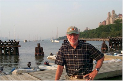
I�ve been a resident of the city for 20 years, making me a relative newcomer, and for most of that time I was of a mind to travel to distant places to be near the sea.� Our boat, a 34� Sparkman and Stephens designed Tartan �classic� built in 1976, was moored for much of its life in Marion, Mass, where the waters of Buzzards Bay, Cape Cod and the Islands offered delightful sailing and convenient ports of call. More extended vacations made possible longer passages to the Bay of Fundy or via the Intercoastal Waterway to the Florida Keys. Until recently I did not think of the city as offering an outstanding area to explore in a small boat. But the traffic of I-95 and the possibility of renting a mooring at the 79th Street Boat Basin within fifteen minutes of our apartment on Manhattan�s Upper Westside changed everything. Now we don�t even have to set sail to appreciate the city in a new way. Only minutes after leaving work on a Friday afternoon we can be on the boat enjoying a spectacular sunset or the sight of windsurfers, kayakers, and cruising sailors from Canada, France or Australia enjoying their boats on one of the nearby guest moorings. Renting a mooring here for $1500 a season or $20 a night is a great way to have a front row seat with a sweeping view of the Hudson, including the George Washington Bridge, the palisades of New Jersey, and the towering apartment buildings of Manhattan�s Upper Westside.� From this prime location one can watch with a deep sense of irony as others set out on the clogged arteries heading for remote locations upstate or to �the island.�� Funny, isn�t it that people refer to Long Island as the island when Manhattan is itself an island and New York City is one of the world�s most interesting archipelagoes. In fact, only 1/8th of the city is on the mainland of the United States, and the city�s inland waterways and ocean beaches give it 578 miles of shoreline -- all within easy reach of anyone with a small boat. In the past five years I�ve explored the cruising grounds located within a half day�s sail from our mooring. �Recently, my wife and I spent a three day weekend scouting these waters in search of additional places where visiting sailors could moor or anchor for the night. We took with us the usual charts, cruising guides and a remarkable book that anyone planning to visit the city by water will want to buy. Namely, William Kornblum�s At Sea in the City: New York From the Water�s Edge.� (Algonquin, 2002). Kornblum provides a wealth of historical and cultural background about this region even as he spins a good yarn about sailing his antique catboat here for many years.� I also interviewed Kornblum about some of the locations we checked out, in some cases updating his narrative. On Friday morning we set sail down the Hudson with a favorable tide, passing the Battery, Ellis Island, the Statue of Liberty and, beneath the sweeping span of the Veranzanno Bridge, glided into the waters of the Lower Bay. Our destination: Staten Island�s Great Kills Harbor. The harbor is spacious and fully protected, a great place of refuge for sailors passing along the coast. On its eastern shore, and clearly visible to starboard as you enter, is a wide expanse of sandy beach, part of the Gateway National Recreation Area.� This is a 26,000 acre park and nature preserve extending from Sandy Hook, New Jersey, along the south side of Staten Island to Jamaica Bay and Breezy Point in the city. Assembled from urban parks, former military sites, and undeveloped marshland, Gateway was established by an act of Congress in 1972 as one of the first urban preserves in the National Park System. That legislation may well mark the beginning of New York Harbor�s rebirth as a recreation area after decades of decline as a commercial shipping port and dumping ground for garbage and industrial waste. Steadily the harbor has come back to life in its contemporary incarnation as a refuge from the stress of the city and a habitat for birds, plants and animals. We spent the entire three day weekend either within or close to Gateway and merely scratched its surface.
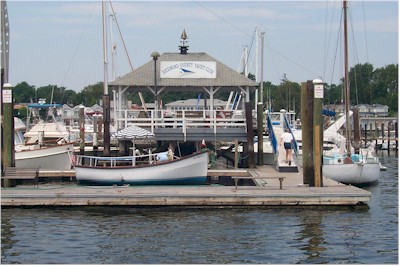
By all appearances, Great Kills Harbor could easily be in Maine or Massachusetts rather than New York City.� Here you will find numerous marinas with a limited number of slips available for transients, but plenty of room to anchor and, we were told, a very large number of moorings available for renting at $25/night from the Richmond County Yacht Club. More expensive than the Boat Basin to be sure, but well worth it as this includes launch service and the club�s shore facilities � showers and, most important, a cozy restaurant. Before calling for the launch to take us ashore for dinner, we enjoyed an eruption of thunder and lightening more dramatic than any 4th of July fireworks display as a cold front swept through the region. This was a one hour sound and light spectacular better than anything on Broadway. As soon as the weather permitted, we contacted the yacht club on VHF channel 9 and were soon on shore. It wasn�t necessary to check out the handful of restaurants within walking distance of the club house, as the best place to eat for visiting sailors is, without question, the restaurant right there at the RCYC.� We sat at the bar and enjoyed two mixed drinks for $5.00. The service is friendly, the surroundings comfortable, and when you combine cost and food quality in the calculation, this is a four star dining opportunity, not to be missed. �Manager Paul Caminity knows how to run a restaurant, and this includes hiring a young staff with real culinary skill eager to impress. We�re planning to return to Great Kills Harbor for another meal here pronto! (The restaurant remains open on weekends through September.) In the morning we motored in our inflatable to Nichols Marina on the east shore of the harbor bordering the Recreation Area. The management here does not cater to the cruising sailor and it�s a long walk to town. We were told, without much enthusiasm, by the individual holding down a chair in the marina office that some slips �might� be available for visiting sailboats at $1.50/ft for the night. There, is however, at the head of the harbor, a public boat launching site where you can pull up in a dinghy and explore the Recreation Area with its beachfront, views and nature sanctuary. We took a four mile run on a beautiful trail with alternating views of the Lower Bay and the harbor. The beach is protected by life guards and there is an excellent landing field for radio controlled air planes. After our run, we motored back to the Yacht Club to explore Hylan Boulevard, the main commercial strip running through Staten Island, an easy walk from the club. Had we spend another night in Great Kills harbor we might well have eaten dinner at a nearby Russian restaurant on Hylan Boulevard. We did not get a good impression of the dining opportunities closer to the club. One longtime Staten Island resident we happened to talk with suggested that restaurant reviews in the Staten Island Advance are meted out according to the amount spent on ads in that newspaper. Alas, we did not have the time, nor the inclination to test this theory. We did, however, wander into Island Trains, a hobby shop featuring Lionel and other brands. These folks have been in the business for more than twenty years, have a wonderful website, and will ship anywhere. Already our morning included not only boats, but planes and trains. �Boys and their toys,� remarked my wife, somewhat less impressed by the morning�s discoveries than I was. Before taking off for our next destination, we returned to the yacht club for a relaxed conversation with Paul who is a goldmine of information about Staten Island and Great Kills Harbor. We spent the remainder of the morning and early afternoon crossing Lower Bay on a light northerly. Old Orchard Shoal, West Bank, Ambrose Channel with all of its shipping traffic, East Bank and the approach to Jamaica Bay framed by Coney Island to the north and Breezy Point to the south. All clear sailing in good weather; I do not enjoy traversing these waters in fog or storm. Without radar, the commercial shipping and high speed ferries, fun to watch when you can see what�s coming at you, become a real threat. As you cross Ambrose Channel in Lower Bay you are perfectly positioned to enjoy the wide sweep of New York City skyline. Not the close up shot most often featured in picture postcards, but the wide angle view that includes Staten Island, the Narrows, Coney Island and the long line of barrier islands stretching off into the distance to the north and east. From this perspective, lower Manhattan is still impressive, but it does not dominate. In fact, you get a more accurate picture of New York as a string of islands interconnected by tidal waterways, bays, rivers and, of course, the ocean. To the south were locations we had previously visited and where sailors exploring the region will find inviting anchorages. Sandy Hook�s Horseshoe Cove is one of these, with Fort Hancock, Sandy Hook Lighthouse, Holly Forest, and North Beach all within an easy walk. If you are looking for the added protection of a mooring field and shore facilities, try the well protected Atlantic Highlands Harbor. Moorings are $35/night from the Atlantic Highlands Yacht Club, including use of the clubhouse facilities located up a long flight of stairs on the second floor of the Shore Casino. There is no restaurant at the yacht club, but from here you can easily walk to the village and First Avenue which includes opportunity for shopping, a marine supply store, and a variety of restaurants. Moreover, from Atlantic Highlands or Horseshoe Cove you can easily spend a day or two exploring the Navesink River which you can navigate, even in a sailboat, as far as Red Bank, New Jersey, about five miles up river. We planned to spend the night in Dead Horse Bay at anchor within what appears on the chart of be a secluded cove on the western shore of Barren Island, but first we wanted to explore Jamaica Bay. To do this one needs to pass beneath the Marine Parkway Bridge with a vertical clearance of 55 feet when closed, as it usually is on weekends. Given that our mast is only 45 feet tall, the passage under the bridge proved uneventful. Still, as you approach such a bridge, from the helm of a small sailboat, even a much taller bridge seems perilously close, and you pray that the stats on the chart are correct. A sailboat mast colliding with a bridge of concrete or steel while being pushed forward by a swift current does not make a pretty picture. Once we were safely under the bridge and into the bay, we began to take in our surroundings. We powered around the eastern shore of Barren Island and into Island Channel. To the east we could clearly see Ruffle Bar and, to the north, Canarsie Pol, islands or hummocks in the middle of the bay that are set aside as a nature preserve. Here we discovered what to me would be a wonderful place to drop anchor for the night. At the entrance to Mill Basin which forms the northern shore of Barren Island there is an area just inside can �9� where� the city seems to fade away almost entirely. In whatever direction you are looking you can see sandy beaches, lined with sea grass and trees. Here one can imagine what the Bay might have looked like long before civilization nearly destroyed it. But the ecosystem here is clearly on the mend. We did not anchor, but as we drifted in the gentle afternoon breeze there appeared on the sandy shore of Bergen Beach on the opposite side of the Mill Basin channel, first one and then a second horse and rider. These lovely animals walked along the beach and into the water as if tempted to swim directly into the bay. There is something magical about a horse and rider by the sea. We did not have the time, but from this point one could easily spend a day or more exploring the waters of Jamaica Bay. In one of the better parts of his book, William Kornblum describes spending three days here aboard his catboat, Tradition. He paints a vivid picture of the abundant wildlife found in the hidden recesses of the bay. �There were waterfowl and other animals in every direction. I saw cormorants, terns, peeps, mallards, ruddies. Up another shadowy bend stood two snowy egrets, with their outrageous yellow boots and platinum punk haircuts.� Indeed there is something magical about the quiet backwaters of Jamaica� Bay, and something quite miraculous about Barren Island where we were to spend the night.� This is the site of Floyd Bennett Field, which was the city�s first municipal airport. Soon eclipsed by La Guardia, it was turned over to the Navy in 1942 and became the busiest military airfield in the U.S. during World War II.� Like Fort Wadsworth on Staten Island or Fort Tilden on the Rockaway Peninsula, these were once military installations important to the defense of the city and the nation. Now they are wonderful places for tourists. Fort Tilden can be reached by bus from Barren Island. This was an active military installation from World War I through the Vietnam War.� Among the activities located in these former military installations there are art exhibits, sporting events, biking, bird-watching, hiking, music and theater performances, nature study, and picnicking. �And they shall beat there swords into plowshares and their spears into pruning hooks,� wrote the prophet Isaiah.� Here, in the midst of New York City, on the anniversary of the Sept 11 terrorist attacks, one will find the prophet�s vision of peace actually realized.
For the evening we sailed from Jamaica back out beneath Marine Parkway Bridge to what we thought would be a secluded anchorage in Dead Horse Bay. On the chart it appears there is a small marina on the north side of the bay and a larger open area with plenty of swing room for an entire fleet of sailboats. Not so. Gateway Marina has just completed a two million dollar expansion that includes a floating breakwater and scores of spanking new piers and slips. The marina now dominates the little bay tilting the balance toward those boaters who prefer to be tethered to shore with electric power, fresh water, hot showers and a convenience store. We succumbed to the comfort of civilization and pulled into one of the slips nearest to the breakwater with an unobstructed view of the Lower Bay. Before dinner we enjoyed a stroll through the community gardens at Floyd Bennett Field, and chatted with members of the Deep Creek Yacht Club who were enjoying a wine and cheese party on the marina pier. (Local sailors may want to consider joining Deep Creek Yacht Club. Annual membership fee: $25!) Also socializing at the marina were members of the Polish Sailing Club who make this a frequent destination on their weekend cruises. After firing up the grill, we enjoyed dinner in the relative privacy of our cockpit, with a spectacular, front row seat for the sunset.� Some low hanging clouds had blown in from the south and as the sun approached the horizon, the sky was a mixture of red, gold, grey and white with blue sky and the sun peeking through. With a change in the wind the aircraft approach pattern into Kennedy was altered and now the jumbo jets began descending through the clouds like a procession of angels from heaven. As the clouds and the darkness thickened the landing lights added a touch of mystical illumination to the cloud cover. On the horizon to the west, the bay was framed with what looked, at this distance, like a medieval castle. Later we learned this is the very up to date campus of �Kingsborough Community College. It frames the bay to the north, while to the south, �there were the twinkling of lights from a few houses on Breezy Point at the end of the Rockaway barrier island separating the bay from the sea. In the morning, we arose to the silence of dawn � flight patterns having been adjusted once more to direct air traffic over a different part of the city. We set sail in a fifteen knot southerly for our mooring at the Boat Basin under genoa and mainsail at hull speed of 6.7 knots. Rounding Coney Island, the view of the Manhattan skyline gradually emerged from the haze and soon we headed for home, wing on wing, with a favorable current behind us. But for the duration of the weekend it seemed we had traveled to distant worlds without ever leaving the waters of New York City.
Please take a moment to let us know you
were here!
If you want to talk with someone in person, please feel free to call 917-439-2305
The Rev. Charles P. Henderson is a Presbyterian minister and is the author of God and Science (John Knox Press, 1986). Charles also tracks the boundry between the virtual and the real at his blog: Next World Design, focusing on the mediation of art, science and spirituality in the metaverse. For more information about Charles Henderson. |
Sponsored Link
|